

 All the advance planning that goes into arriving at a job site on time — predictive scheduling, automated dispatching, computerized map routing — can go for naught the minute traffic snarls up unexpectedly. But technology is catching up to the problem. Google, for instance, recently launched an update to its maps to provide live traffic data for 130 new U.S. cities by using the real-time movement of Android phones to create live traffic flows. Drivers can re-route the moment they see that fender-bender slowing things down.
Here are five top navigation apps to help fleet managers and drivers stay on schedule:
TomTom
One of the most popular in-vehicle navigation systems, TomTom offers drivers real-time traffic reports and advice on alternative routes on most of its models. Dubbed “HD Traffic,” the service updates drivers every two minutes with road conditions, taking data from a variety of sources — including other drivers with HD Traffic. The catch: live-traffic updates cost extra ($60 per year), on top of the cost of the device, which can run upwards of $200, depending on the model.
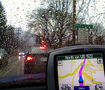
Garmin
Similar to TomTom, Garmin’s in-car traffic system alerts drivers to delays and can automatically re-route drivers around trouble spots. Garmin’s service culls traffic data from other Garmin users, incident reports, radio feeds, historical data, and smartphone-user movement on the roads. Its service is free on supported navigation models, with free lifetime software updates to boot.
Magellan
This other popular GPS navigation device offers three ways for drivers to get traffic data:
- Buy a unit with traffic included as a standard feature;
- Get an add-on device called “Traffic Link” that connects to the existing Magellan navigation unit;
- Purchase a “traffic subscription” for a traffic-integrated Magellan device. Magellan also offers lifetime traffic alerts.
Sigalert.com
This app, available for Android and iOS, taps into the state highway patrol’s traffic data and uses road sensors for accurate readings on everything from accidents to construction. One of the issues with maps on in-vehicle devices like those from TomTom and Garmin is that the user interface can leave a lot to be desired, especially when compared to maps on smartphones that are easy to zoom and swipe. As an app, Sigalert features maps that are clickable and zoomable. It’s free, but with a fee, users can get customizable routes. The one drawback is that it’s only available in larger metropolitan areas, so the tech in Nowheresville, USA won’t have much use for it.
Motion X GPS Drive
Another app (the best-selling traffic app in Apple’s App Store), Motion X, offers GPS service for the iPhone and iPad. One neat feature is a Wikipedia button that gives a summary of, and directions to, locations near your destination. It also features live traffic routing and incident information via a partnership with INRIX, a real-time traffic information provider. The app is 99 cents, though turn-by-turn navigation costs more money.
More: Google Coordinate: Easy Dispatching for the Masses.
Click here to download a free whitepaper, “Five Steps to Make Field Service Profitable.”

Share this: